How Do Supercells Form?


Supercells are a particular type of thunderstorm distinguished by a persistent, rotating updraft called a mesocyclone. This rotating updraft plays a crucial role in propelling supercells to become the powerhouses of severe weather. Unlike regular thunderstorms, supercells have the potential to produce a wider range of extreme weather events with greater intensity, including tornadoes, large hail, damaging winds, and torrential rain.
This article by thedailyECO delves into the science behind supercell formation. We'll explore the atmospheric conditions necessary for their development, the role of the mesocyclone, and the different classifications of supercells. We'll also examine the potential consequences of these powerful storms.
What is a supercell?
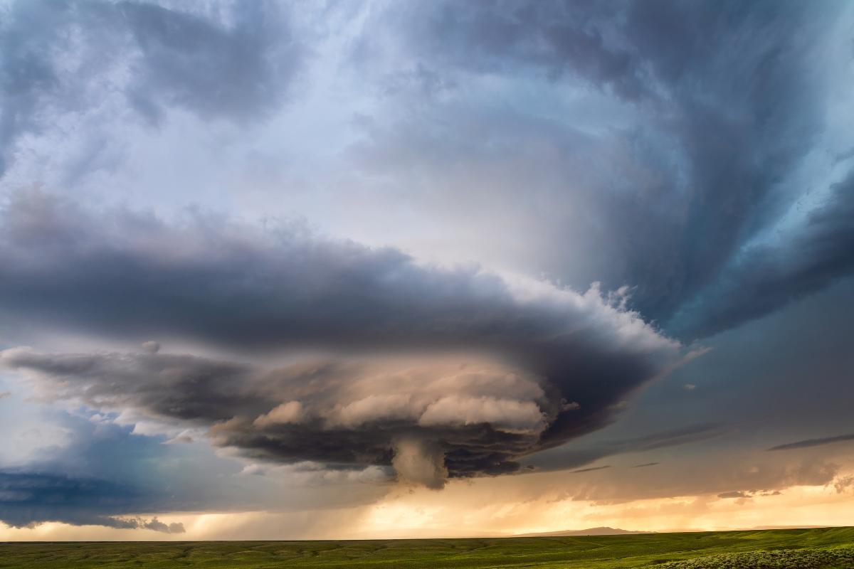
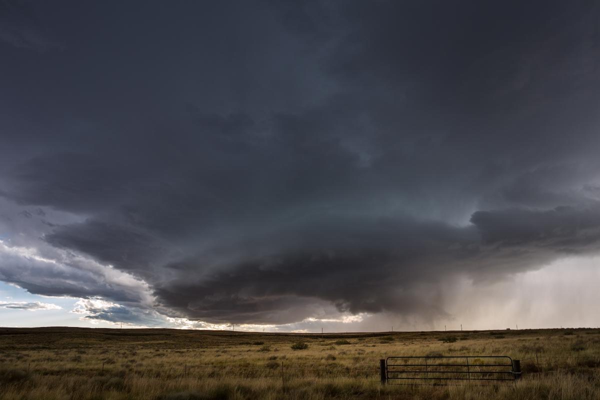
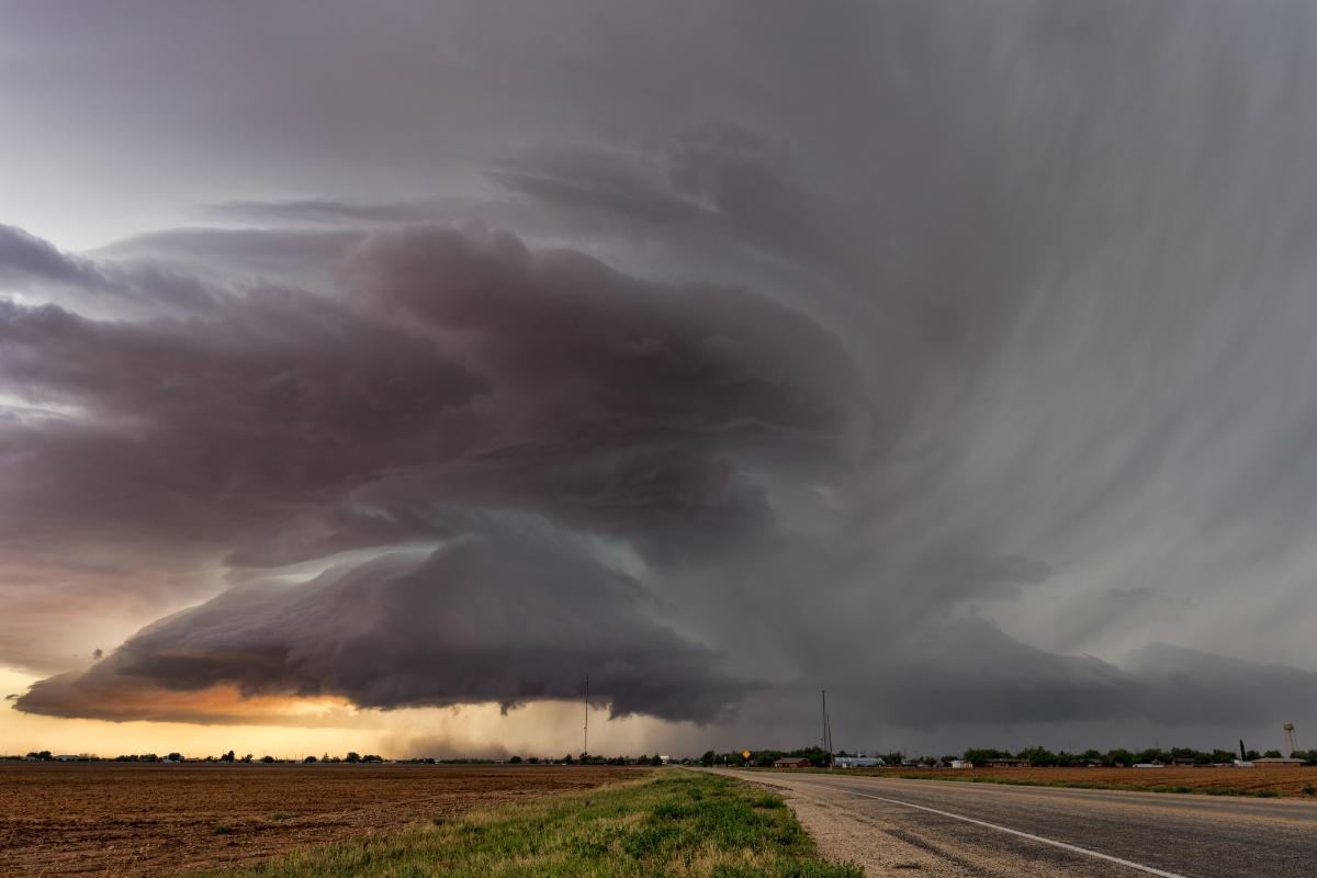
Supercells are intense thunderstorms distinguished by a rotating updraft, the mesocyclone. This persistent rotation fuels their power, allowing them to produce a broader range of severe weather compared to regular storms.
The mesocyclone, a vertically rotating air column, is the engine of the supercell. Wind shear, changes in wind direction with altitude, initiates this rotation. As the air spins, it stretches and weakens, further intensifying the updraft. This powerful, sustained updraft is key to supercell development.
The strong updraft and rotating mesocyclone create an environment for severe weather like tornadoes, large hail, and damaging winds. Understanding supercell formation improves severe weather forecasting and warnings.

How does a supercell form?
The formation of a supercell is a complex process that depends on specific atmospheric conditions and dynamic interactions. Ample moisture in the lower and middle layers of the atmosphere is crucial, as it provides the necessary fuel for cloud and storm formation. This is how supercells are formed:
- It all starts with abundant moisture in the atmosphere. This moisture acts as fuel for the storm, providing the energy needed for development and maintaining the powerful updrafts characteristic of supercells.
- The next ingredient is instability. This refers to warm air near the ground and cooler air aloft. This temperature difference creates an environment where warm air wants to rise rapidly.
- Now, just warm air rising wouldn't create a supercell. Here's where wind shear comes in. Wind shear is a change in wind direction and speed with increasing altitude. As warm air rises, this wind shear acts like a giant whisk, "stirring" the air column and initiating a rotation. This rotation is the seed for the powerful mesocyclone.
- The wind shear's "stirring" motion sets the stage for the formation of the mesocyclone, a vertically rotating column of air within the storm. As the air spins, it stretches and weakens, further intensifying the updraft. This powerful, sustained updraft becomes the engine of the supercell, allowing it to grow and reach tremendous heights.
This combination creates an environment favorable for producing severe weather phenomena like tornadoes, large hail, and damaging winds.
Supercells eventually dissipate due to several factors: reduced wind shear, movement into an area with less moisture or instability, or when precipitation cuts off the supply of warm, moist air to the storm's base.
Do not miss this other article where we discuss other atmospheric electrical phenomena.
Types of supercell
Supercells can be classified into different types, each with distinct characteristics that affect their behavior and destructive potential:
Classic supercells
This is the most common type, often visualized when discussing supercells. These supercells have a well-organized structure, often with a funnel or wall-shaped cloud base. They produce intense rainfall and large hail. Classic supercells are known for producing a wide range of severe weather, including tornadoes, large hail, and damaging winds.
High precipitation supercells
These storms generate substantial precipitation, including heavy rain and hail. They form in environments with abundant moisture and produce copious amounts of rain and hail. The mesocyclone in an HP supercell can be partially obscured by the heavy precipitation, making it difficult to visually identify. However, their destructive potential should not be underestimated because these produce large hail and tornadoes embedded within the heavy rain.
Low precipitation supercells
These supercells produce much less rain compared to other types, resulting in more visible storm structures. They are often found in drier environments where less moisture is available for condensation and rainfall. LP supercells can still be quite dangerous, producing large hail and strong winds due to their strong updrafts and rotation.
Other Variations
Beyond these common types, there are less frequent variations like:
- Double-sheared supercell: Two distinct wind shear zones at different altitudes influence the rotation.
- Mini-supercell: A smaller version of a classic supercell, typically forming during cooler seasons.
Have you ever heard of dry storms? We tell you all about this fascinating phenomenon in this other article.
What damage can a supercell do?
Supercells, due to their intense and persistent nature, can lead to several serious and widespread consequences:
- Supercells are the most likely storms to produce tornadoes, ranging from weak to extremely violent in intensity.
- The strong updraft within a supercell can suspend ice particles for extended periods, allowing them to grow into significant sizes before falling.
- Downdrafts within supercells can generate high-speed winds, sometimes comparable to tornado winds.
- Certain supercells, especially those with high precipitation, can unleash enormous amounts of rain quickly, leading to flash floods, river and stream overflows, and urban flooding.
- Supercells are prolific producers of lightning, both within the cloud and towards the ground.
- Damage caused by hail, tornadoes, winds, and heavy rainfall results in substantial economic losses for individuals, businesses, and governments.
The extent of the damage caused by a supercell depends on several factors, including:
- Strength of the storm: More powerful supercells naturally pose a greater threat.
- Location of the storm: Developed areas with dense populations are more susceptible to widespread damage.
- Topography of the land: Hilly or mountainous terrain can exacerbate flash flooding.
Ever witnessed lightning that strikes endlessly? The Catatumbo lightning is a natural wonder. You can learn more about it in our other article.

What makes a supercell different from a typical thunderstorm?
Supercells and regular thunderstorms are both convective storms, meaning they form due to rising warm, moist air. However, supercells stand out for their unique features and the potential for unleashing significantly more severe weather.
The defining characteristic of a supercell is the presence of a mesocyclone, a vertically rotating updraft within the storm. This persistent rotation is absent in regular thunderstorms.
Also, supercells boast much stronger updrafts compared to regular thunderstorms. The mesocyclone helps to focus and intensify these updrafts, allowing them to reach much higher altitudes (often exceeding 10 km) compared to a typical thunderstorm's updraft (around 5-7 km).
The combination of the rotating mesocyclone and strong updrafts creates an environment within a supercell that's particularly favorable for producing a wider range of severe weather phenomena, such as damaging winds and tornadoes.
While not a definitive factor, supercells often exhibit a more well-defined, vertically-stacked structure with a distinct anvil cloud shaped like a blacksmith's anvil at the top. Regular thunderstorms can display a wider variety of shapes and cloud formations.
If you want to read similar articles to How Do Supercells Form?, we recommend you visit our Meteorological phenomena category.
- Nicolini, M. (2009). Supercells. The COMET Program- May 2002-UCAR.
- What is a Supercell? National Weather Service. National Oceanic and Atmospheric Administration. Yellow, TX. Weather Forecast Office. Available at: https://www.weather.gov/ama/supercell
- Dolce, Ch. May 6, 2024. Supercells: What to Know About These Dangerous Thunderstorms
- El Canal del clima. Available at: https://weather.com/science/weather-explainers/news/supercell-thunderstorms-tornadoes


